Destination
Nepal

An adventurous journey in Nepal’s heartland, the Makalu Base Camp Trek offers incredible scenery. Starting from Tumlingtar village in the Sankhuwasabha district of Nepal, the trekking trail traverses several traditional villages and resting places. Initially, the travelers pass through Khandbari, Chichila, Num Camp, Seuda, Tashi Gaon, Kauma, Mumbuk, Neha Kharka, Sherson, and finally reach Makalu Base Camp.
There is a diverse ethnic population of Nepali tribes living in the region, including Brahmins, Chhetri’s, damais, and Dalits, along with ethnic Bhotia Gurung, Sherpa, Rai, Limbu, Magar, and Tamang groups in the highlands. Traditional lifestyles still prevail in the Makalu villages, isolated from modern-day civilization and maintaining a conventional way of life. Additionally, the Makalu civilization survives on farming and animal husbandry. Despite the region’s weak economy, you can still experience a very strong cultural heritage in this region.
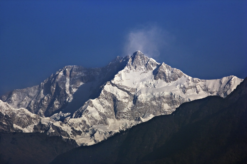
The Makalu Base Camp resides inside the Makalu Barun National Park at an elevation of 5250 meters, dominated by beautiful nature. The Makalu Barun National Park is the most beautiful natural region, and it is home to Mount Makalu, the 5th tallest mountain in the world. You will be blessed with the spectacular beauty of the Makalu region and panoramic views of a wide range of mountains, including Mt. Makalu (8,481m), Mt. Everest (8,848m), Mt. Lhotse (8,516m), Mt. Chamlang (7,319), Mt. Baruntse (7,220m), Peak 7 (6,185m), Peak 6 (6,739m), and many others. Mount Everest shows an eastern face that you have probably never seen before, even in photographs. Additionally, you will enjoy the scenic view of glacial lakes, giant glaciers, and picturesque valleys.
Trekking in the Makalu region is restricted; therefore, a special permit is required from the government of Nepal. “Makalu Base Camp Trek” offers a variety of ecosystems. Most of the trail is remote and isolated, so it will be super adventurous, wild, and off-the-beaten-track. Makalu Base Camp Trekking is perfect for anyone looking for a less crowded trek in the Himalayas.
Although this trek is not easy on the difficulty scale, it has a high score on the beauty and adventure scale. Makalu Base Camp Trek offers wilderness, breathtaking natural scenery, amazing culture, and raw adventure. Despite being considered a hiking trail for experienced hikers, this trek can be done even by beginners with some preparations and guidance.
Table of Contents
The total Makalu Base Camp Trek Permits costs an estimated range of USD 1700-1850 per person, which includes two different permits:
In general, the trek to Makalu Base Camp takes more than 20 days. Furthermore, the trail is challenging since you gain more than 5,000 meters in elevation. If not done properly, there are also chances of altitude sickness. Here are the factors which make Makalu Base Camp Trekking a challenging expedition in the Himalayas.
Makalu Base Camp Trek does not rank among the easiest hikes. It takes a lot of dedication and perseverance to reach this natural paradise. With its natural splendor, the Makalu region is an exclusive package of trekking destinations with its remoteness, unpredictable weather, high altitude passes, few trekking amenities, and changing terrain.
Trekkers with prior trekking experience can hike to Makalu Base Camp without much difficulty. However, don’t let your novice status discourage you from trekking. Any experienced trekking agency will manage the trek, assigning a team of guides and porters to ensure that you have the best experience possible. However, being physically fit is necessary to complete the trek without fear. Whether it is your first-time trekking in Nepal, you can succeed with proper preparation.
Depending on Nepal’s altitude and location, the duration and severity of the seasons will vary. Since the winters at high altitudes are longer, the snow doesn’t melt as soon as it falls. Every year, the length of the seasons varies. For instance, in the past, the monsoon would end around mid-September. It has been common for monsoonal rains to extend into October over the last five years.
There is a reason why autumn is considered the best season to trek in Nepal. Skies are clear, and rainfall is low. The days are sunny and pleasant. At night, temperatures won’t drop too far. Even so, the mercury may fall below freezing at night due to the variation in altitude. At altitude, you lose 6°C on average per 1,000 meters. From September to November, high passes are less likely to be blanketed in snow. It is recommended that you pay special attention to the weather on the day of crossing Kauma La, Tutu La, and Keke La due to the unpredictable nature of changing climate in the Himalayas.
Some traces of the monsoon can still be seen in the skies in September. The rain may not fully cease until the final week of September. From Kathmandu to Tumlingtar, rain, fog, and cloud cover can disrupt flight schedules. It’s best to be prepared for the worst. Between the first weeks of October and mid-December is the best time to trek to Makalu Base Camp. However, due to heavy and repeated snowfall in high altitudes during the autumn trekking season of 2019, some high passes remained closed for a few weeks.
Trekking Makalu Base Camp during spring is the second-best time to go. Despite its warmer-than-average temperature, Spring can sometimes bring snowfall to high altitudes. High passes are more likely to be trampled by snow and ice. There is still a good amount of clear sky, so mountain views remain mesmerizing. With summer fast approaching, the temperature continues to rise. During this season, the surroundings are awash with greenery, and a myriad of colors as wildflowers and Rhododendrons are in full bloom.
Snow and rain can still be expected between March and May, even after the winter recedes from the mountains. In 2019, heavy snowfall blocked trekking routes during February and March, and it took longer than expected for them to reopen. That’s why we recommend keeping an eye on the weather forecast before venturing out on a remote trail. It is crucial to stay in touch with your travel agency for weather forecasts before proceeding to high passes in remote areas like Makalu Base Camp, where internet connectivity does not exist.
If you take extra precautions, trekking in Nepal is still possible during the winter or monsoon. To tolerate high and low temperatures and unstable weather conditions. Trekking can be done even in the off-season if you prepare well and use the weather window to cross three passes between days five and eleven. Makalu Base Camp Trek offers you exceptional experiences accompanied by marvelous and outstanding views in each season. Be sure to check the weather forecast in advance to avoid being stuck in the middle of the trail without shelter. It is often a good idea to check with your guide, as well as the teahouse owner, for updates on the weather.
One of the best parts of hiking during the off-season is that the number of trekkers will significantly decrease. Moreover, you will be able to take advantage of cheaper and discounted rates for food and accommodation. If you want to avoid the harsh cold during winter, you can prepare by having extra warm clothes, gear, and a flexible itinerary to avoid sudden weather changes and snowfalls. During winter, high-elevation residents descend to lower terrain. Many tea houses may close during the peak winter season.
MONSOON
The lower altitudes of Nepal experience heavy rainfall during this season. Consequently, flooding and landslides are possible. With the rise in temperatures and the erratic and heavy rain and humid weather, insects such as mosquitoes and leeches can be a nuisance during the trek. While trekking during the monsoon season, you should pack a raincoat, rain boots, rain cover, insect repellent, and heat defender. As in the winter, you can also find special offers and discounts on accommodations and food during this season.
Throughout the year, the Makalu Base Camp trek remains stunning and exciting. It doesn’t matter if you prefer a pleasant climate or if you prefer to experience the extreme weather conditions in the mountains. Makalu Base Camp is always open to visitors.
Our representative will meet you at the Tribhuvan International airport and transfer you to your hotel. In the evening, you can explore Kathmandu or take a day of rest.
Usually, the flight takes 35 minutes, and you get spectacular views of the mountains if there aren’t any clouds. A winding road leads uphill for about 30 minutes to Kandbari, where the government officials are located. There are plenty of local scenes to experience as you head upward with fields of corn, bamboo, and sal trees. From there, you descend on a winding dirt road to 1,960m before reaching Chicula at 1,900m, a small town with a police checkpoint. The surrounding hills are covered in forest. Since Chicula is a bit downhill, the ride to Num is bumpy. It’s not unusual for your vehicle to get stuck, either behind a tractor-trailer or on the muddy, rocky road. Locals are typically willing to help you out if you are in a bind! There is also the option of taking a public bus from Kathmandu to Tumlingtar, which takes about 11 to 12 hours.
After breakfast, we walk steeply downhill for about 800 meters from the western end of the village to Arun River through a forest of Shima trees, Chestnuts, and Pines. Within the forest is a cardamom plantation as well. As you walk steeply uphill to Seduwa, we cross a suspension bridge over Arun River. Despite the heat and humidity, the trail is well shaded by the forest. In the morning, we enter the Makalu Barun National Park and register our permits. You might have lunch at Seduwa, since it is the only tea house between these camps. The Arun valley and its surrounding ridges present us with a stunning landscape.
A gentle and gradual uphill trail makes this a more pleasant day than the previous. In small villages, tea shops are available where you can stop for tea and snacks. Before reaching Tashigaon, we pass a Rai settlement and a Chhorten. The panoramic mountain views from Tashigaon make for a wonderful lunch.
Today, you will have a lot of climbing to do! The climb begins with stone steps ascending out of Tashigaon. The trail ascends through a rhododendron forest after crossing a log bridge.
In approximately three hours, you will arrive at the tea shop in Dhara at 2,867m, where you are likely to have lunch since it’s your last chance to refresh yourself before you reach Khongma. From Dhara it’s a steep climb of about an hour to Unshisa at 3,200m, passing a giant rock. After Unshisa, the steep ascent continues through a rhododendron forest on stone steps. A good deal of snow-covered this part of the trail in April 2019, making the going somewhat challenging. From Unshisha, it takes a couple of hours to reach a stone rest stop with prayer flags, followed by another 15 minutes, or another 1/2 hours, to reach 3,560m Khongma Danda.
Acclimatization is crucial, so we recommend that you hike up the Khongma La . The path leads through rhododendron bushes to the 3,890m pass as you step on stone steps. You should reach the pass within an hour. Once you return to Khongma, you are fit and acclimatized, ready to take on the four passes tomorrow, the first of which is the Khongma La.
This day offers high passes, airy traverses and dramatic ridge sections with near-constant views of snow-capped peaks. In April, you may encounter snow, so be prepared. You will probably have lunch in Dobate rather than Shipton La, so take plenty of snacks and water with you as you’ll have a long, tough day (you might be given a packed lunch today). The Khongma La at 3,890m is your first pass of the day, and it takes about an hour to ascend through rhododendron bushes. Depending on the weather, you will be able to see Makalu and Chamlang from there. A short descent follows before ascending to the second pass. As you traverse an airy ridge, you can enjoy views of Kangchenjunga. You can reach Sano Pokhari Danda at 4,105m, overlooking Sano Pokhari Lake. A trip from the Khongma La will take you around an hour, although navigating through snow will take longer. You will reach the highest pass along the way – Shipton La at 4,200m. A tea shop/tin shelter serves thirsty, tired trekkers and pilgrims during the season. A prayer flag-draped cairn and a mani wall mark the pass near the shelter. Up to Shipton La is a steep climb, but not too difficult.
The terrain descends less steeply to the Kalo Pokhari Lake at 4,080 meters. Hindu pilgrims visit the shrine during January Purnima Festival to pray. The Keke La, at 4,170 m, is the last climb of the day. Your lodge at Dobate awaits you after another 45 minutes of descent – a wonderful sight after the long four-pass trek!
We descend steeply towards the Barun River today, which can be tricky due to lingering snow. After reaching the river, you begin walking on a trail underneath a landslide area. The view of Chanlang and Tutse is impressive in the morning.
Having climbed a short distance, you reach the tea shop at Themathang Kharka, 3,500 m. This destination can be reached in around four hours from Dobate. Just before you get to Themathang, you will encounter an impressive waterfall. Following this, you walk for a short distance until you cross a wooden bridge over Baron Khola. In places near Yangle Kharka, stony paths have been constructed quite extensively. A trip to Yangle Kharka and your lodging for the night takes approximately one and half hours from the tea shop at Themathang. It’s a wild and windswept place. A monastery is near the street from the lodge, providing an attractive foreground for pictures with snow-covered mountains in the background.
On the way to the river and small monastery, you descend from your hut. The path begins on a flat, pleasant slope, keeping the river on your left and smelling of juniper as you walk. Along the trail, you can see many colourful prayer flags. A dramatic cliff rises on either side of you, and there is a view ahead that includes Peak 4, Peak 6, Peak 7 and Yaupa. This is truly a glorious day, complete with jagged snow-covered peaks, vertical cliffs, waterfalls, and sacred caves.
After 2.5 hours of hiking, you reach Merek, where a welcome tea shop awaits you after passing Jhak Kharka, Yak Kharka, and Yak Kharka pastures. There’s a good chance you’ll indulge in a cup of chai here before continuing upward. Taking it slow and steady here will undoubtedly be a challenge since you’ll feel the altitude as you trudge up to Langmale. Getting to Langmale tea house from Merek takes around 2 hours. With a backdrop of Peak 7, these lodge rooms have some of the best views in the world. A row of rooms is surrounded by a mani wall adorned with prayer flags. Choughs and black redstarts make regular appearances here.
Today, there are a few options for acclimatization. You can walk as far as your guide suggests behind the tea house as there is a nice hill and viewing point.
Starting on a good path, the ascent can be difficult at this altitude, so be cautious. During your trip around the valley, keep the river to your left. You will discover new dramatic aspects as you round each bend. Most of the time, you’re on a sandy trail, hopping from boulder to boulder. The trail undulates gently, and there are only a few steeper sections to tire you out.
After an hour or so of hiking, you will reach a wide, flat area with a locked stone hut. At 4,630m, this is known as Shershong, and it makes an ideal camping spot. Eventually, Makalu looms before the eyes. Glancing up at its formidable face, you are amazed by its icefalls, crevasses, jagged edges, and seracs. Around a few bends, you wonder when you’ll see the base camp. As you approach the base camp, you will see the lodges and (if it is spring) a huddle of tents. This view is completely dominated by the world’s fifth highest mountain, Makalu. The base camp is a haven for Tibetan snowcocks, hill pigeons, black redstarts, and mountain finches.
Climbing to the ridge – 5,300m above the base camp – will give you today’s most majestic panoramic views. After crossing the river on the log bridge, you ascend along a vague, slightly indeterminate path for approximately 3 hours. This viewpoint provides close-up views of Makalu, Peak 7, Peak 6 and Peak 4, and Everest, Lhotse and Nuptse. Retrace your steps back to the base camp once you have had your fill of mountain drama. It should take you 4-5 hours to make the round trip. Since the terrain is steep and above 5,000m, it will be a difficult task.
Several softer options are available, including hiking beyond the base camp to view the lakes. You can do a much shorter ridge climb just above base camp, and there is a small hill at the head of base camp marked with prayer flags that take about an hour to hike out and back. You can also ask your guide for other suggestions.
The overwhelming spectacle that is Mount Makalu leaves you with a heavy heart as you begin your return to Yangle Kharka. A tarp with a bright orange color marks the meadow of Shershong, which takes approximately 1.5 hours to reach. You will then return to Langmale, where you may have tea and possibly lunch. After walking downhill for 1 hour, you reach Merek Tea Shop. You can relax here with a cup of chai before you make your way back to Yangle Kharka through pine forests. There is a travel time of approximately 2-2.5 hours from Merek to here. You will be welcomed with a hot shower for 200 rupees.
This is a truly lovely walk following the river down to the tea shop at Themathang, passing many rhododendron bushes along the way. In front of Themathang, you can cross a wooden bridge decorated with prayer flags. The trip takes 1.5 hours.
Within a short time, you will have to navigate the landslide area, which will take approximately 1.5 hours. Be careful passing through some narrow sections. After an undulating stretch, you begin climbing steeply through the rhododendron forest. Perhaps you can see a Himalayan monal here – Nepal’s national bird, known for its rainbow-coloured plumage. Once you reach the hut at Dobate, the going begins to ease, and the ascent becomes gradual. Unless you stop at the tea shop at Themathang, which occurs early in your walk, you will not find another refreshment stop until you reach Dobate, so pack plenty of snacks.
Take advantage of the last chance to see Kangchenjunga, one of the world’s highest peaks. Starting from 4,170m, you climb to Keke La in 1.5 hours. The Shipton La at 4,200m will take an additional 1.5 hours to reach your highest point today. Have a nice break at the tea house here. After another hour of contouring the mountainside, you’ll reach the large cairn that marks Sano Pokhari Danda at 4,105 m. It takes another hour to reach the final pass – the Khongma La at 3,890m, marked by a massive mani wall. After approximately 250m of downhill walking, you get your lodge at Khongma. The blood pheasant, which can sometimes be seen wandering in the snow between the rhododendron bushes, can sometimes be seen.
The descent from Khongma to Dhara Kharka takes about 2 hours. You’ll probably stop here for a cup of tea. From there, it takes 3 hours to reach Tashigaon.
It will take around 4-5 hours to retrace your steps back to Seduwa today.
From the Arun River at 770 meters, there is a fairly long, steep descent on stone steps. The lower you go into the forest, the warmer it will get. Then, you cross the river and climb 800 meters back to Num. It’s a good idea to have lunch at Nishan ‘Hotel’ – a tea house about 300m below Num. This challenging trek is now over, and you can congratulate yourself on completing it.
After breakfast, you will be transferred to Tumlingtar airport for your return flight to Kathmandu, where you will be met and transferred to your hotel. You can relax and recuperate from your exertions for the rest of the day.
Stay and explore places